Map Overview and Navigation |
  
|
Map Overview and Navigation |
|

The map displayed in LINK is a set of organized but individual layers composed in your browser as a complete map. Layers are the geographic datasets managed, maintained, and compiled by your GIS staff or consultant. Individual layers may include operational data (e.g. parcels, utilities, and roads) or basemaps (e.g. aerial imagery, elevation data, or geologic data). Each layer contains geographic information and tabular information. The geographic information of each layer can be measured, buffered, and queried with the tools available in LINK. The tabular information can be searched, sorted, and exported.
The basemaps have been cached or "pre-drawn" at a fixed number of scales to maximize the drawing speed during map navigation. For a more detailed explanation of the map layers see the map layers section.
There a few ways to navigate the map:
•Keyboard shortcuts
•The Zoom Slider
•The Navigation Tools
Keyboard and Mouse Action |
Link Map Result |
|---|---|
Clicking and dragging (without any tools active) |
Pans the Map |
Rolling scroll wheel back and forth |
Zooms the map in and out |
Pressing and holding SHIFT key while dragging a rectangle with the mouse |
Zooms in on the rectangle |
Pressing the Control and E key simultaneously |
Returns map to the full extent |
To zoom to the cached scales you can use the Zoom Slider bar.
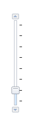
• You can click on the up arrow ![]() or down arrow
or down arrow![]() to navigate between map scales to obtain the scale they wish to work in the map with.
to navigate between map scales to obtain the scale they wish to work in the map with.
•The Zoom Slider bar can also be used to reach the desired map scale by dragging the slider up or down between map scales.
To see additional methods of navigating the map review the Navigation Tools section.